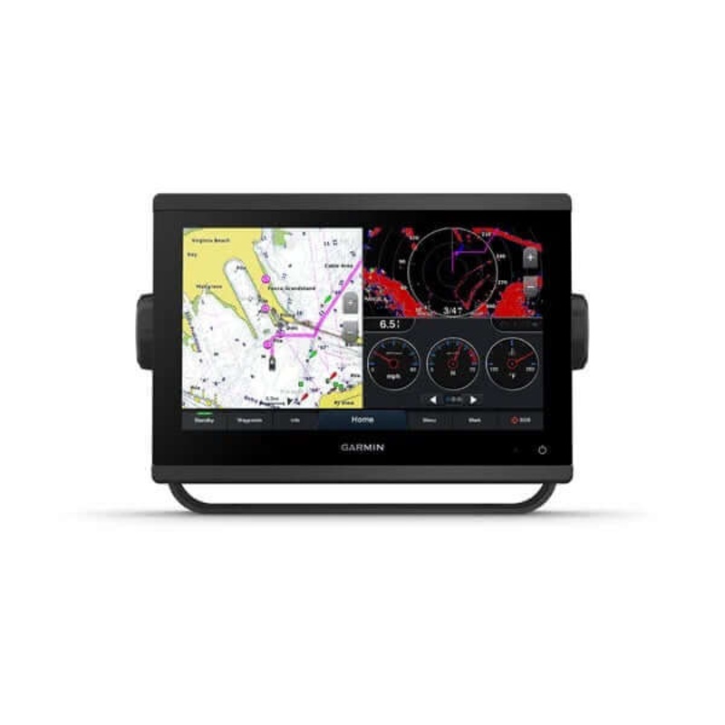
Garmin GPSMAP 943 Chartplotter with BlueChart g3 coastal charts and LakeV g3Model: 010-02366-01Easily integrate with more engines.Connect to compatible third-party devices with OneHelm digital switching.Easily build your marine system using the best of net
![]()
Garmin GPSMAP 943 Chartplotter with BlueChart g3 coastal charts and LakeV g3
Model: 010-02366-01
With 60% more display pixels and nearly double the processing power of previous-generation 9″ GPSMAP devices, this crisp high-resolution chartplotter integrates seamlessly into your Garmin marine system.
With its added processing power and new slimline design featuring edge-to-edge glass and a smaller unit footprint, its easy to retrofit this 9″ plotter in a wider range of dash configurations.
New higher-resolution 9″ displays offer improved sunlight readability with 60% more pixels than previous-generation 9″ GPSMAP devices.
Experience unparalleled coverage and detail with preloaded BlueChart g3 coastal charts and LakeV g3 inland maps featuring integrated Garmin and Navionics content and Auto Guidance technology.
Upgrade to our reliable premium charts3, which add even more unparalleled features, such as high-resolution relief shading, to help you on each trip.
View laylines, race start line guidance, enhanced wind rose, heading and course-over-ground lines, true wind data fields and tide/current/time slider, wind angle, set and drift, wind speed and more.
Specifications
| General | |
| PHYSICAL DIMENSIONS | 9.2″ x 6.4″ x 3″ (23.3 x 16.2 x 7.6 cm) |
| DISPLAY SIZE | 7.8″ x 4.4″; 9.0″ diagonal |
| DISPLAY RESOLUTION | 1280 x 720 pixels |
| DISPLAY TYPE | WXGA display |
| WEIGHT | 3.6 lbs (1.6 kg) |
| WATER RATING | IPX7 |
| POLARIZED SUPPORT | Yes |
| POWER CONSUMPTION | Max power usage at 10 Vdc: 22 W Typical current draw at 12 Vdc: 1.3 A Max current draw at 12 Vdc: 1.8 A |
| ANTENNA | Internal or external over NMEA 2000 |
| MOUNTING OPTIONS | Bail, flush or flat |
| RECEIVER | 10 Hz high-sensitivity |
| GARMIN MARINE NETWORK PORTS | 1 |
| Maps & Memory | |
| PRELOADED MAPS | BlueChart g3 (coastal maps) and LakeV g3 (inland maps) |
| ACCEPTS DATA CARDS | 2 microSD cards (back of unit) |
| WAYPOINTS | 5,000 |
| TRACK LOG | 50,000 points; 50 saved tracks |
| ROUTES | 100 |
| Outdoor Recreation | |
| TIDE TABLES | Yes |
| Chartplotter Features | |
| GARMIN RADAR COMPATIBLE | Yes |
| GARMIN SONAR COMPATIBLE | Yes (with external black box, sold separately) |
| GARMIN SMARTMODE COMPATIBLE (CUSTOMIZABLE MONITOR PRESETS) | Yes |
| SUPPORTS AIS (TRACKS TARGET SHIPS POSITION) | Yes |
| SUPPORTS DSC (DISPLAYS POSITION DATA FROM DSC-CAPABLE VHF RADIO) | Yes |
| SUPPORTS FUSION-LINK COMPATIBLE RADIOS | Yes |
| GSD BLACK BOX SONAR SUPPORT | Yes |
| GCV BLACK BOX SONAR SUPPORT | Yes |
| ACTIVECAPTAIN COMPATIBLE | Yes |
| GRID (GARMIN REMOTE INPUT DEVICE) COMPATIBLE | Yes |
| WIRELESS REMOTE COMPATIBLE | Yes |
| SAILING FEATURES | Yes |
| Sonar Features & Specifications | |
| CHIRP SONAR TECHNOLOGY | Yes (with external black box, sold separately) |
| CLEARV | Yes (with external black box, sold separately) |
| SIDEV | Yes (with external black box, sold separately) |
| Connections | |
| NMEA 2000 COMPATIBLE | Yes |
| NMEA 0183 INPUT PORTS | 1 (Differential) |
| NMEA 0183 OUTPUT PORTS | 1 (Differential) |
| VIDEO INPUT PORTS | 1 BNC |
| WIRELESS CONNECTIVITY | Yes |
| J1939 COMPATIBLE | Yes |
What’s in the Box:
,
Garmin GPSMAP 943 Chartplotter with BlueChart g3 coastal charts and LakeV g3
Model: 010-02366-01
With 60% more display pixels and nearly double the processing power of previous-generation 9″ GPSMAP devices, this crisp high-resolution chartplotter integrates seamlessly into your Garmin marine system.
With its added processing power and new slimline design featuring edge-to-edge glass and a smaller unit footprint, its easy to retrofit this 9″ plotter in a wider range of dash configurations.
New higher-resolution 9″ displays offer improved sunlight readability with 60% more pixels than previous-generation 9″ GPSMAP devices.
Experience unparalleled coverage and detail with preloaded BlueChart g3 coastal charts and LakeV g3 inland maps featuring integrated Garmin and Navionics content and Auto Guidance technology.
Upgrade to our reliable premium charts3, which add even more unparalleled features, such as high-resolution relief shading, to help you on each trip.
View laylines, race start line guidance, enhanced wind rose, heading and course-over-ground lines, true wind data fields and tide/current/time slider, wind angle, set and drift, wind speed and more.
Specifications
| General | |
| PHYSICAL DIMENSIONS | 9.2″ x 6.4″ x 3″ (23.3 x 16.2 x 7.6 cm) |
| DISPLAY SIZE | 7.8″ x 4.4″; 9.0″ diagonal |
| DISPLAY RESOLUTION | 1280 x 720 pixels |
| DISPLAY TYPE | WXGA display |
| WEIGHT | 3.6 lbs (1.6 kg) |
| WATER RATING | IPX7 |
| POLARIZED SUPPORT | Yes |
| POWER CONSUMPTION | Max power usage at 10 Vdc: 22 W Typical current draw at 12 Vdc: 1.3 A Max current draw at 12 Vdc: 1.8 A |
| ANTENNA | Internal or external over NMEA 2000 |
| MOUNTING OPTIONS | Bail, flush or flat |
| RECEIVER | 10 Hz high-sensitivity |
| GARMIN MARINE NETWORK PORTS | 1 |
| Maps & Memory | |
| PRELOADED MAPS | BlueChart g3 (coastal maps) and LakeV g3 (inland maps) |
| ACCEPTS DATA CARDS | 2 microSD cards (back of unit) |
| WAYPOINTS | 5,000 |
| TRACK LOG | 50,000 points; 50 saved tracks |
| ROUTES | 100 |
| Outdoor Recreation | |
| TIDE TABLES | Yes |
| Chartplotter Features | |
| GARMIN RADAR COMPATIBLE | Yes |
| GARMIN SONAR COMPATIBLE | Yes (with external black box, sold separately) |
| GARMIN SMARTMODE COMPATIBLE (CUSTOMIZABLE MONITOR PRESETS) | Yes |
| SUPPORTS AIS (TRACKS TARGET SHIPS POSITION) | Yes |
| SUPPORTS DSC (DISPLAYS POSITION DATA FROM DSC-CAPABLE VHF RADIO) | Yes |
| SUPPORTS FUSION-LINK COMPATIBLE RADIOS | Yes |
| GSD BLACK BOX SONAR SUPPORT | Yes |
| GCV BLACK BOX SONAR SUPPORT | Yes |
| ACTIVECAPTAIN COMPATIBLE | Yes |
| GRID (GARMIN REMOTE INPUT DEVICE) COMPATIBLE | Yes |
| WIRELESS REMOTE COMPATIBLE | Yes |
| SAILING FEATURES | Yes |
| Sonar Features & Specifications | |
| CHIRP SONAR TECHNOLOGY | Yes (with external black box, sold separately) |
| CLEARV | Yes (with external black box, sold separately) |
| SIDEV | Yes (with external black box, sold separately) |
| Connections | |
| NMEA 2000 COMPATIBLE | Yes |
| NMEA 0183 INPUT PORTS | 1 (Differential) |
| NMEA 0183 OUTPUT PORTS | 1 (Differential) |
| VIDEO INPUT PORTS | 1 BNC |
| WIRELESS CONNECTIVITY | Yes |
| J1939 COMPATIBLE | Yes |
What’s in the Box:

Reviews
There are no reviews yet.